The Boogeyman, by The Toy Zone


Recently, a writer at BuzzFeed, Sara Thompson, decided to see what would happen when she asked Midjourney what a typical person from each American state looked like (AImericans?). These are the three from the states I’ve lived in, but you can see all 50, here.
Why does Indiana seem the only state that’s happy?
(via @mymodernmet.com)


In his ongoing series titled Thin Places, Portland-based photographer Brendon Burton documents battered houses that stand alone in barren fields, amidst an encroaching marsh, or at the edge of the mountain. The decrepit structures have been Burton’s preferred subject matter since 2011 when he began seeking abandoned buildings across the continent that exude a sense of impermanence and the uncanny. “This series is for the sake of satisfying my curiosity about the past and exploring isolated parts of North America. It mixes archeology with fantasy,” he says.
(via This is Colossal)
Take a look at this interesting world map with the literal names of countries, commissioned by Credit Card Compare (which I think is something like NerdWallet).


In June of 2005, I enjoyed a Black and Black (Guinness with two shots of espresso) at Temple Bar in Temple Bar—Dublin’s much older version of NYC’s Greenwich Village, riddled with tourists and students from the nearby Trinity University, which is, in turn, Dublin’s version of the much older NYU. The final swig of the drink was captured digitally by Mike, and somehow made it’s way to NewsToday and QBN design forums and their insidious PSBs.
Two weeks ago, I returned to Temple Bar and Mike thought it would be fun to recreate the photo from 8.5 years before. Above are the two pictures side-by-side. Below is an animated gif created by Google Plus’s “auto-awesome” feature. In all three photos, I’m in dire need of a good shave and notice my default wardrobe (V-neck black T-shirt) hasn’t changed much over the decade:

As I wait in jittery, excited anticipation of my big trip back to the old country to see the rustic villa where my grandfather was born in 1909, I have been asking a number of friends about their recommended off-the-beaten-path must-dos in Italy.
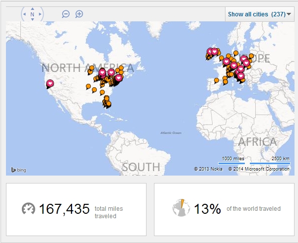
I was initially quite proud of this until I visited some of the travel maps of friends, which look like glitteringly decadent Christmas trees. My lowly map, if you notice, has no dots west of the Mississippi—which will change for Todd’s wedding this July—and only sparse locations in Eastern Europe. I’ve been to less than half of the world’s continents and have predominantly traded in dollars, pounds and euros (and pre-euro currencies). And while I’m struggling to become less sedentary, I’m merely posting this pitiful map to show to the friends who’ve asked about my previous travel experiences.
That said, if you find yourself in any of the following locations this June, let’s get a Prosecco and Peroni:
– Rome
– Naples
– Siena
– Florence
– Chianti
– Anywhere in Tuscany
– Anywhere on the Amalfi Coast
– Anywhere on the Ligurian Sea
And, if you’ve been there before, let me know of some things you recommend!
I’ve been following the success of UMapper (formerly GMap, provided by the good folks at AFComponents.com) since a client of mine asked ERA404 to build a dating search with results based on proximity around a geographic area. And while the site has taken a slightly different direction since then, UMapper piqued my interest. In their latest newsletter, they cited creating Google Maps-style widgets from any image. And sure enough, it works!
I started to think of all the useful applications this could have for my companies and clients. For instance, Lyrek CEMS, which manages our clients’ contacts, events and venues, could plot their contacts on a world map. Clients seeking geographic searches (such as the dating site, previously mentioned) could now brand and custom design their national or global maps. Game developers and Facebook Application developers could use this functionality for GeoDart Games and MapWikis. And who is to say that the map has to be a geographical representation of land? Any application where a user would want to plot points of interest/note on a 2D plane would work: It could be a hi-rez scan of an organ or anatomical figure for physician studies, or a zoomed micro electron slide of pond water for biological research. The possibilities are endless.
And with AFComponents/UMapper’s analytics tools, you can also create surveys, questionnaires, tests/quizzes, census studies and a whole host of other information-gathering applications.
Watch their video, here: