MTA Map – Currently

MTA Map – Massimo Vignelli’s 1972 Design

MTA Map – New, Proposed Design
New York City’s subway system has a new map with a very old design concept, inspired by Massimo Vignelli‘s 1972 classic. Read more
New York City’s subway system has a new map with a very old design concept, inspired by Massimo Vignelli‘s 1972 classic. Read more


After much research, University of Chicago sophomore Sasha Trubetskoy has completed a subway-style map of the road system of the Roman Empire. From about 300 BC, the Romans built or improved over 250,000 miles of roads (50,000 miles were stone paved) that extended into the farthest reaches of the Empire: from Spain to modern-day Iraq to Britain to northern Africa.
(via Kottke.org)
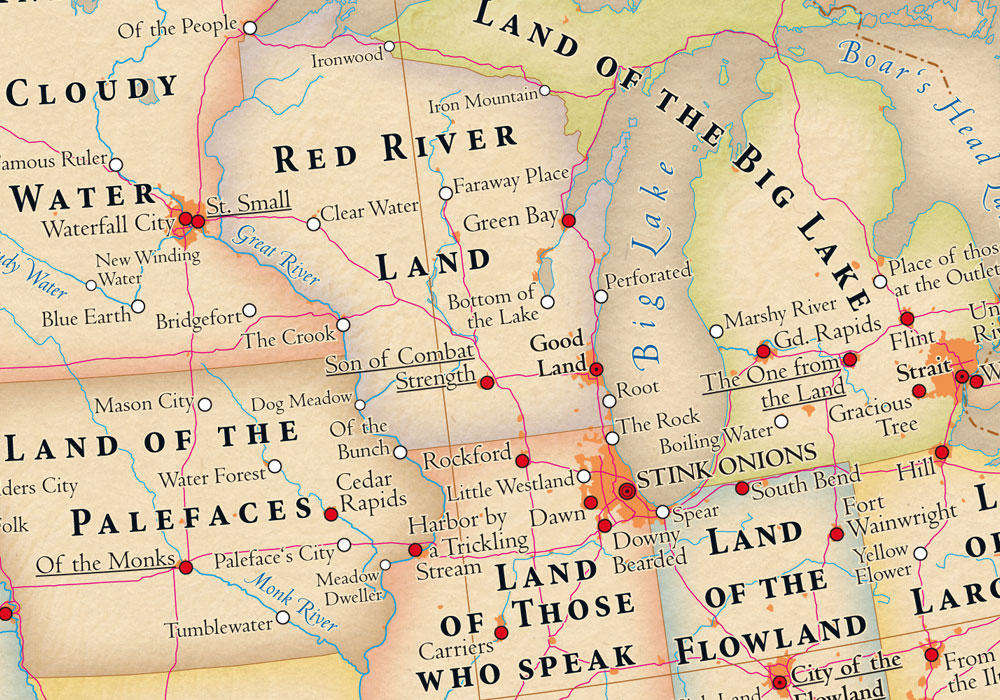
I was delighted to see that my hometown, Kalamazoo (“Boiling Water”), made its way onto The Atlas of True Names. Read more

Using geo data from photos uploaded by users to Google’s Panoramio, Sightsmap generates an interactive heatmap of the most frequently photographed spots around the world. It reminds me a little of the Heat Map I made back in 2006, which could be applied to any geolocational data (including photos).
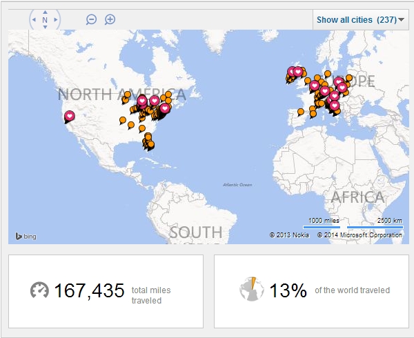
As I wait in jittery, excited anticipation of my big trip back to the old country to see the rustic villa where my grandfather was born in 1909, I have been asking a number of friends about their recommended off-the-beaten-path must-dos in Italy.
I was initially quite proud of this until I visited some of the travel maps of friends, which look like glitteringly decadent Christmas trees. My lowly map, if you notice, has no dots west of the Mississippi—which will change for Todd’s wedding this July—and only sparse locations in Eastern Europe. I’ve been to less than half of the world’s continents and have predominantly traded in dollars, pounds and euros (and pre-euro currencies). And while I’m struggling to become less sedentary, I’m merely posting this pitiful map to show to the friends who’ve asked about my previous travel experiences.
That said, if you find yourself in any of the following locations this June, let’s get a Prosecco and Peroni:
– Rome
– Naples
– Siena
– Florence
– Chianti
– Anywhere in Tuscany
– Anywhere on the Amalfi Coast
– Anywhere on the Ligurian Sea
And, if you’ve been there before, let me know of some things you recommend!
I’ve been following the success of UMapper (formerly GMap, provided by the good folks at AFComponents.com) since a client of mine asked ERA404 to build a dating search with results based on proximity around a geographic area. And while the site has taken a slightly different direction since then, UMapper piqued my interest. In their latest newsletter, they cited creating Google Maps-style widgets from any image. And sure enough, it works!
I started to think of all the useful applications this could have for my companies and clients. For instance, Lyrek CEMS, which manages our clients’ contacts, events and venues, could plot their contacts on a world map. Clients seeking geographic searches (such as the dating site, previously mentioned) could now brand and custom design their national or global maps. Game developers and Facebook Application developers could use this functionality for GeoDart Games and MapWikis. And who is to say that the map has to be a geographical representation of land? Any application where a user would want to plot points of interest/note on a 2D plane would work: It could be a hi-rez scan of an organ or anatomical figure for physician studies, or a zoomed micro electron slide of pond water for biological research. The possibilities are endless.
And with AFComponents/UMapper’s analytics tools, you can also create surveys, questionnaires, tests/quizzes, census studies and a whole host of other information-gathering applications.
Watch their video, here: