When I was a kid, I had a dream that when you die, you’re taken to a room in heaven where a red line traces your existance on the world, darting in and out of streets, houses, colleges, towns, states, countries, etc. This way, even if your work didn’t leave an indelible line on society, your steps surely would. In the dream, I saw the lines intersect with my family and then split off again. The lines tangoed with lovers (and glowed more vividly when they crossed), meandered with friends, sped down highways on roadtrips and caromed off near misses with soul mates, only to intertwine again. The pulsing line, so full of activity, only ended when you were laid to rest for good. It’s a stupid dream, but, hey, I was a kid.
I’ve always been charmed by the idea of connecting myself with the world. It’s one of the main reasons I designed the parent site of Donline, Citarella.net. This is where my family can connect with other branches in the tree. It’s also why I created the flickr map gallery of my family members, the Heat Map, and why Mike and I worked on creating myhoboken.info (which enables businesses in the Hoboken area to plot themselves on maps with logos). I thought that was pretty innovative, since no one else seemed to do it at the time, but I’ve just learned of the GeoTag feature of Picasa2 and Google Earth.
If you’ve never seen this, it’s definitely something exciting to look at. GeoTags enable you to create an external Google Earth file that links to your images in Picasa to plot exactly where they were taken in the world. It goes one step beyond that to have the file load when you’re browsing through Google Earth to see a smattering of your photos on the planet.
It’s actually quite simple to do.
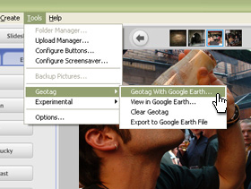
1. Locate an image in Picasa2.

2. Click “Tools” –> “Geotag” –> “Geotag in Google Earth”
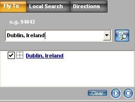
3. Search for your location in Google Earth.
(ie. “Dublin, Ireland”)
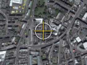
4. Crosshairs will appear on the aerial map of the earth. Drag the crosshairs to exact the location where the picture was taken.
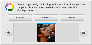
5. Click “Geotag” from the Picasa2 pop-up to confirm your location.
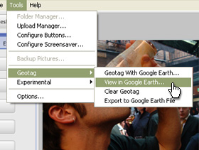
Now, you’re done. See how easy that was? If you want to view your Geotags, browse to the image in Picasa2 and click “Tools” –> “GeoTag” –> “View in Google Earth”
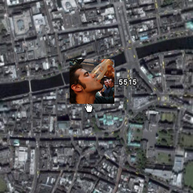
It’ll open up Google Earth again and pinpoint the picture on the globe. Here’s me drinking a Black-n-Black (Guinness and Espresso) in Temple Bar Pub, in Temple Bar, Dublin, Ireland.
Give it a try for yourself!